

NYC Zoning
Understanding NYC Zoning
New York City's Zoning Resolution governs how every parcel of land can be used and developed. Knowing the rules is the first step to unlocking a property's full potential.
What is the Zoning Resolution?
The New York City Zoning Resolution, first adopted in 1961, is the set of regulations that controls land use and building development across all five boroughs. It determines what can be built on a given lot, how large it can be, and how it must relate to the street and neighboring properties.
Every lot in New York City is assigned a zoning district. That district determines permitted uses, maximum building size, required open space, parking requirements, and more. Understanding your property's zoning designation is essential before any development, renovation, or acquisition decision.
Quick Reference
- RResidential districts — R1 (low-density) through R10 (high-density)
- CCommercial districts — neighborhood retail through major office corridors
- MManufacturing districts — light industrial through heavy industrial uses
- FARFloor Area Ratio — the primary control on building density and size
Zoning districts
NYC's zoning map divides the city into three broad categories, each with multiple sub-districts that regulate density and use.
Residential Districts (R1–R10)
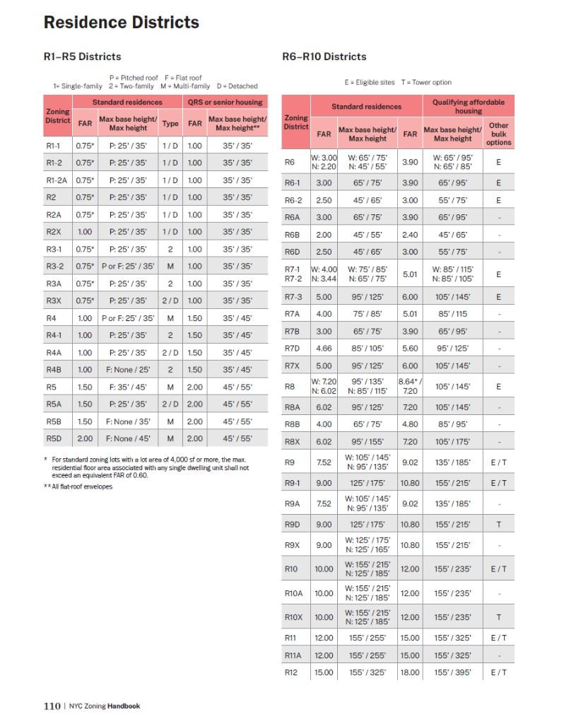
Range from low-density detached homes (R1) to high-density apartment towers (R10). Each sub-district sets maximum Floor Area Ratio, building height, setbacks, and permitted dwelling types. R1–R5 are primarily low-rise; R6–R10 allow mid- and high-rise residential development.
Commercial Districts (C1–C8)
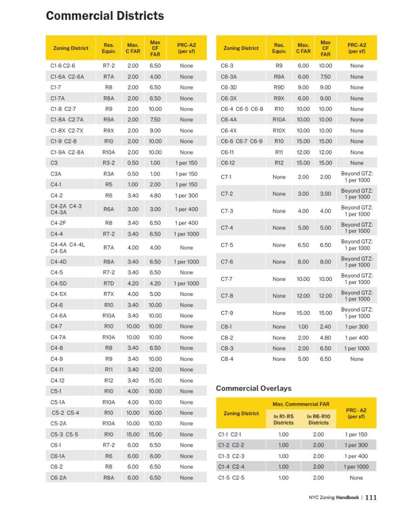
Permit retail, office, hotel, and mixed-use development. C1 and C2 districts are typically mapped as overlays on residential zones to allow neighborhood retail. C4–C6 allow larger commercial and office uses. C8 districts accommodate auto-related and heavy commercial uses.
Manufacturing Districts (M1–M3)
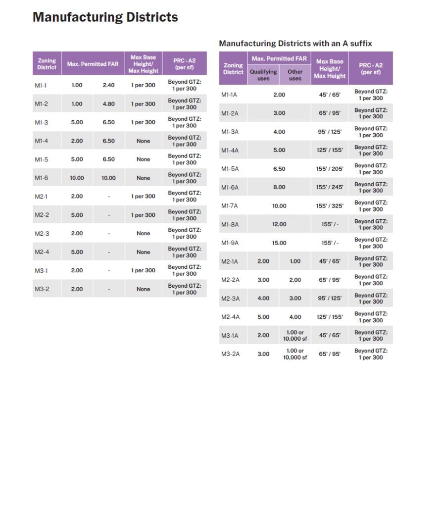
Designed for industrial, warehouse, and manufacturing uses. M1 is the lightest category and often borders residential or commercial zones. M3 allows the heaviest industrial uses. Many M1 districts have been rezoned in recent decades to permit residential and mixed-use development.
Reference tables
FAR, height limits, and bulk specifications for every zoning district in New York City. Source: NYC Zoning Handbook.
Residence Districts (R1–R12)
Commercial Districts & Overlays (C1–C8)
Manufacturing Districts (M1–M3)
Key zoning concepts
Floor Area Ratio (FAR)
FAR is the ratio of a building's total floor area to the area of its lot. A 5,000 SF lot with an FAR of 2.0 allows up to 10,000 SF of floor area. FAR is the primary tool for controlling building density in NYC.
Use Groups
The Zoning Resolution organizes permitted uses into 18 use groups — from single-family homes (Use Group 1) to heavy manufacturing (Use Group 18). Each zoning district specifies which use groups are permitted as-of-right or by special permit.
Bulk Regulations
Bulk regulations control a building's size and shape: maximum height, required setbacks, sky exposure planes, and lot coverage. These rules ensure buildings relate appropriately to the street and neighboring properties.
As-of-Right Development
A project that complies with all applicable zoning regulations can proceed as-of-right — without discretionary review or public hearings. Understanding what is permitted as-of-right is critical to efficient project planning.
Variances & Special Permits
When a project cannot comply with zoning regulations, a developer may seek a variance or special permit from the Board of Standards and Appeals (BSA) or City Planning Commission (CPC). These processes involve public review and are not guaranteed.
Rezonings & ULURP
Changing a property's zoning designation requires a Uniform Land Use Review Procedure (ULURP) — a multi-step public review process involving the community board, borough president, City Planning Commission, and City Council.
Special districts & overlays
Beyond the base zoning districts, NYC has dozens of special purpose districts, commercial overlays, and contextual zoning designations that modify the underlying rules. These include Special Mixed-Use Districts, Inclusionary Housing designations, Mandatory Inclusionary Housing (MIH) areas, and Transit Zone designations — all of which can significantly affect what is permitted on a given site.
Mandatory Inclusionary Housing (MIH)
Requires affordable units in new residential developments in designated areas.
Transit Zone
Areas near transit where parking requirements are reduced and certain ADU types are permitted.
Special Mixed-Use Districts
Allow residential and light industrial uses to coexist in the same building or block.
Contextual Zoning
A-suffix districts (R6A, R7A, etc.) impose stricter height and setback rules to match existing neighborhood character.
How Empire Properties Partners uses zoning
Our team analyzes zoning conditions on every project we evaluate — identifying as-of-right development potential, special permit opportunities, and rezoning pathways. Whether you are acquiring a site, planning a renovation, or exploring an ADU addition, understanding the zoning envelope is where every project begins.
- Zoning due diligence on acquisitions and development sites
- As-of-right envelope analysis to maximize buildable area
- ADU eligibility assessment under current and updated zoning
- Coordination with architects and expediters on permit strategy
Have a property you want to evaluate?
Our team can assess your site's zoning conditions and development potential.